Planning a Northern Ontario road trip itinerary is the ultimate way to swap city skyscrapers for the ancient granite of the Canadian Shield. In August 2020, we traded our 850-square-foot Toronto apartment for 12 days of wilderness, driving from the urban sprawl to the rugged shores of Lake Superior and beyond. This loop takes you through the province’s most iconic landscapes—from the white water bridges of Pukaskwa to the towering cliffs of Sleeping Giant and the turquoise waters of the Bruce Peninsula. In this guide, I’ll share our exact 12-day route, camping highlights, and the hidden gems we discovered along the way.
After months of being stuck at home and future out of country travel plans in limbo, my roommate and I decided we needed a real vacation. One that allowed us to really distance ourselves from work since our offices were now our bedrooms. 850 sq feet seemed big a few months ago but now it's our entire world. With COVID cases decreasing throughout Ontario, we decided it was safe enough to plan a camping road trip through Northern Ontario. We found 3 eager friends who wanted to join us and started planning!
This post will cover our itinerary from a high level. Each section will link to a more detailed post about a specific park. We squeezed a lot in but it was all worth it!
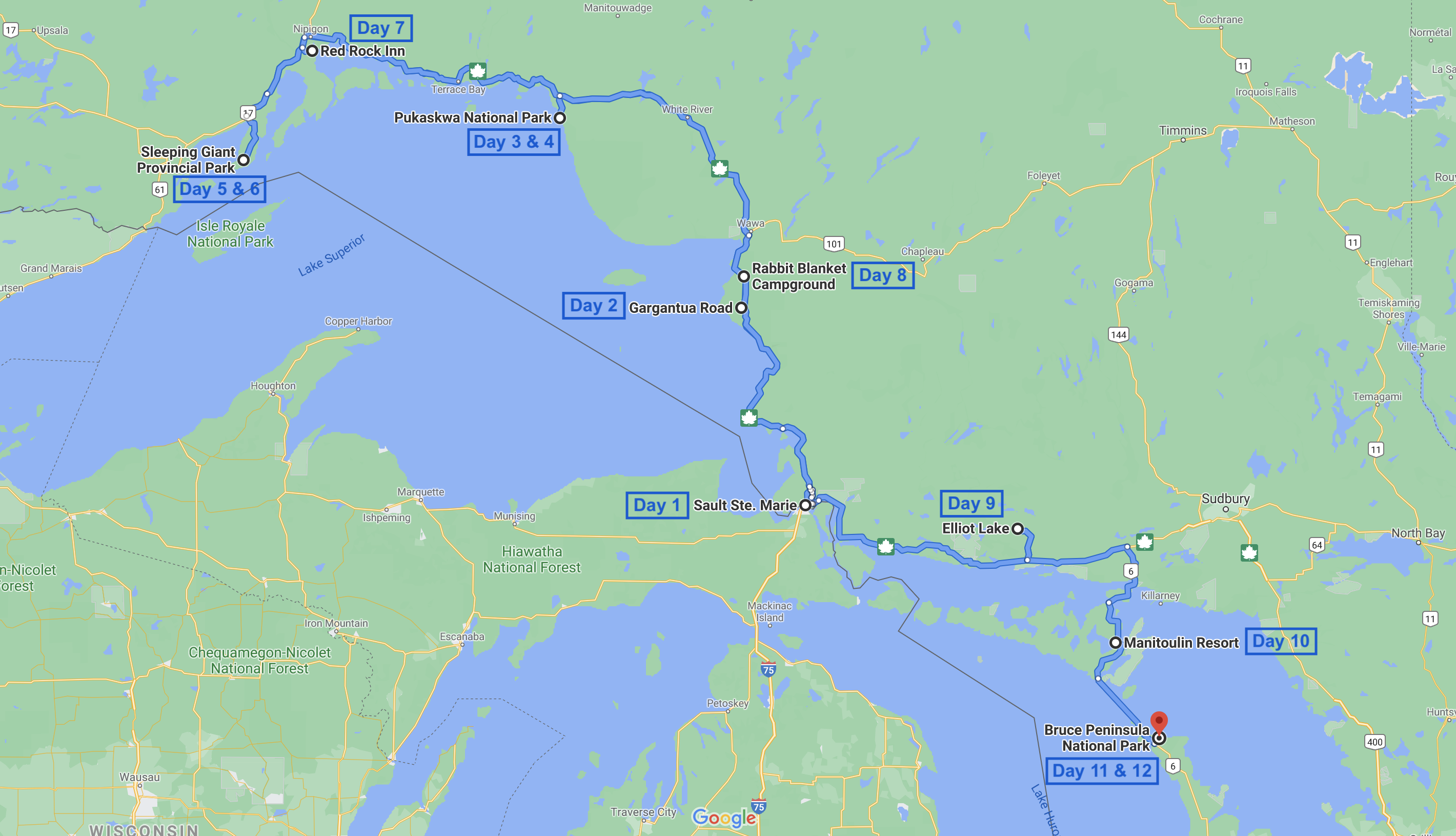 Full Itinerary Map Can be Found Here
Day 1 - Sault Ste. Marie: Our trip started with a 7 hour drive from downtown Toronto to the Quattro Hotel in Sault Ste. Marie. We stopped in Parry Sound, just over 2 hours into our drive, for dinner and a quick leg stretch. Although it was already pretty late at night we had to make one last stop, 20 minutes from our hotel, to see the Giant Loonie in Echo Bay.
Day 2 - Lake Superior Provincial Park: Full Blog Post ✍️
- Pancake Bay Lookout: ~50 minute drive from Sault Ste. Marie to the start of the 7km return lookout trail.
- Agawa Rock Pictographs: 800m return hike to an indigenous archaeological site to view the Ojibway people's 17th or 18th rock paintings.
- Gargantuan Bay, Backcountry Camping: 30 minute drive down a windy gravel road to a secluded Bay where we backcountry camped on the beach.
❤️ My favourite park from our trip! ❤️
Day 3:
- Manito Miikana Trail: 2km return hike to a couple lookout points on Lake Superior with beautiful views of forested islands in the distance.
- oTENTik Frontcountry Camping: A mix between a rustic cabin and a tent, we had a very comfortable sleep this night with a delicious barbequed meal.
Day 4:
- Coastal Trail to the White Water Suspension Bridge: A challenging 18 km return hike through dense forest to a picturesque suspension bridge overlooking the white water rapids below.
- Beach Trail: After a long hike, we were ready to lounge at the beach and watch the sunset. This easy 1.2km return trail was worth the extra steps after a long day.
- Hattie Cove, Frontcountry Camping: Although this campsite was entirely first come first serve, we were shocked to find that it was half empty and had very private sites. Don't miss out on this underrated National Park.
⭐ Ontario must see! ⭐
Day 5:
- Terrace Bay, Aguasabon Waterfall: On our way to Sleeping Giant, we made a quick detour to see the impressive Aguasabon Falls. This powerful waterfall is just a short walk from the parking area and made for a perfect leg stretch after hours in the car.
- Sea Lion Trail: A short but scenic 1.6km trail that takes you to a rocky outcrop resembling a sea lion.
- Tee Harbour Trail: We hiked this moderate 5km trail down to the shores of Tee Harbour, where we'd be camping for the night.
- Tee Harbour, Backcountry Camping: Our most remote campsite of the trip, although very popular so you're not isolated. Camping here makes the big hike to sleeping giant easier the following day.
Day 6:
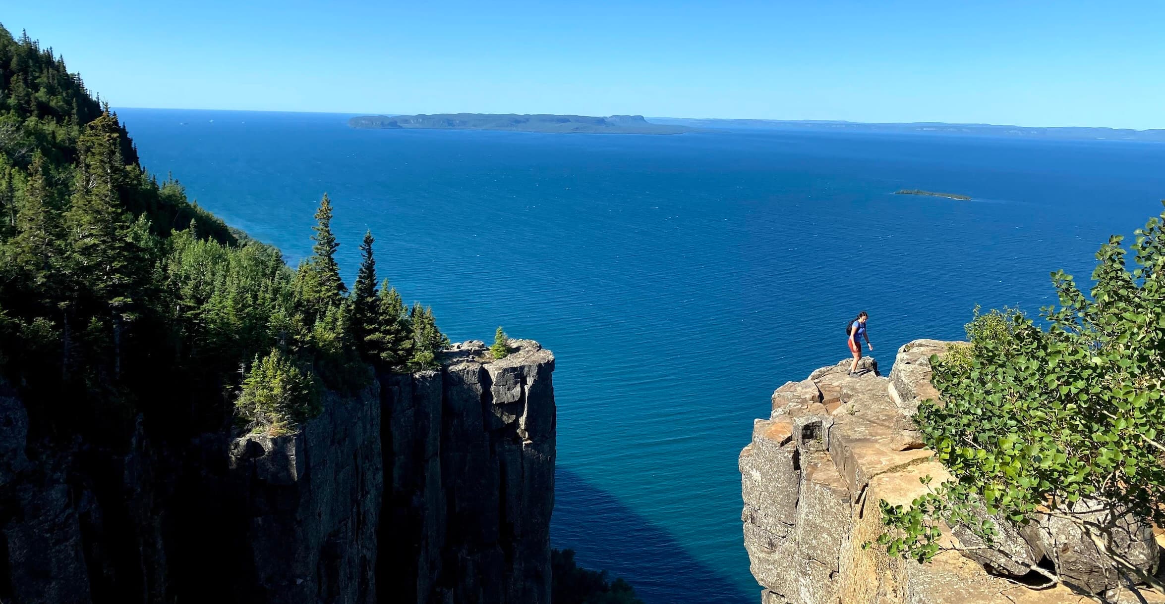
- Top of The Giant Trail: The park's signature hike and absolutely worth the effort. This challenging 17km return trail took us to the top of the Sleeping Giant formation. The panoramic views from the summit were breathtaking, but our legs definitely felt it afterwards.
- Eagle Canyon Suspension Bridge: After checking out of the park, we stopped at this privately operated attraction featuring Canada's longest suspension footbridge.
- Ouimet Canyon: Our final stop of the day was this dramatic gorge with sheer cliffs dropping 100 meters. The short walk from the parking lot leads to viewing platforms with incredible views of the canyon walls and unique arctic-alpine plants growing at the bottom.
Day 7:
- Red Rock Inn: After backcountry camping, we treated ourselves to a hotel stay at this local spot. We really recommend staying here, the owners are very sweet and gave us great local recommendations for the rest of our trip.
- Nipigon Recreation Trail: A relaxing walk along the Nipigon River. This paved trail was an easy stroll perfect for stretching our legs without too much exertion after the previous day's challenging hike.
- Secret Waterfall: A local hidden gem we discovered from the recommendation of the Red Rock Inn owners. The small waterfall tucked into the forest felt like our own private discovery.
- Rabbit Blanket Campground, Lake Superior Provincial Park: We returned to Lake Superior Provincial Park for another night, this time at a different campground. Rabbit Blanket Lake offered a peaceful setting and great swimming.
Day 8:
- Katherine Cove: Before leaving the park, we spent the morning at Katherine Cove. This beautiful sandy beach on Lake Superior was the perfect spot for a final swim and some relaxation before hitting the road.
- Elliot Lake: We drove to Elliot Lake and stopped at the Fireside grill for dinner. This was a highly recommended local spot and it lived up to the hype. We stayed at the Hilton hotel that night.
Chutes Provincial Park: Our first stop on Manitoulin Island was this small park featuring beautiful waterfalls. The short trails made it an easy morning activity.
Township of Little Current: We grabbed lunch in this charming town and explored the local shops. Little Current serves as the main hub of Manitoulin Island and has a lovely waterfront area. This is also a great spot to pickup groceries.
Cup And Saucer Trail: The highlight of our Manitoulin Island visit. This 10km loop trail features stunning views from the highest point on the island. The white quartzite cliffs and panoramic vistas made this one of our favorite hikes of the entire trip.
Manitoulin Island Resort & Campground: There are no provincial or National park campgrounds in the island so you will need to find a private one if you want to car camp. We set up camp at this lakeside resort for the night. The facilities were excellent and the sunset views over the water were gorgeous.
Day 10:
- Chi-Cheemaun Ferry: We took the ferry from South Baymouth on Manitoulin Island to Tobermory on the Bruce Peninsula. The ferry ride itself is huge, and offered beautiful views of Georgian Bay.
- The Bruce Trail: Once we arrived at Bruce Peninsula National Park, we hiked a section of the famous Bruce Trail. The turquoise waters and dramatic limestone cliffs along the shoreline were unlike anything we'd seen on the trip so far.
- Stormhaven Backcountry Camping: We hiked to our backcountry campsite at Stormhaven for our final two nights of camping. The site sits right on Georgian Bay with incredible water access. These are very popular campsites so we had to book them the day they become available, months before our trip.
Day 11:
- Stormhaven Backcountry Camping: We spent the day relaxing at our campsite, swimming in the crystal clear waters of Georgian Bay, and exploring the rocky shoreline. After so many days of hiking and driving, a slower day was much needed.
- The Grotto: In the afternoon, we hiked to the park's most famous attraction. This natural sea cave with its bright blue water was absolutely stunning, though it was also the most crowded spot we'd encountered on the entire trip.
Day 12:
- Final Day, Driving Home: We packed up our campsite one last time, hiked back to the car, and began the journey home. After nearly two weeks of camping, hiking, and exploring Northern Ontario, we were exhausted but filled with incredible memories. And after a 4 hour drive home, we were back in Toronto.
We found that 12 days is the perfect "sweet spot" for this loop. It allows you enough time to complete the major multi-hour hikes (like Top of the Giant and the Coastal Trail) while still having a few slower afternoons for swimming and recovery.
Yes, absolutely! Ontario Parks (Provincial) allows bookings 5 months in advance, and popular spots like Lake Superior and Sleeping Giant fill up fast. For Bruce Peninsula National Park, the Grotto parking and Stormhaven campsites often sell out the moment they are released.
The stretch of Highway 17 between Sault Ste. Marie and Wawa is arguably the most beautiful drive in the province. The road hugs the rugged coastline of Lake Superior, offering constant views of the water and the ancient rock of the Canadian Shield.
Be prepared for significant "dead zones." While Sault Ste. Marie and Thunder Bay have great coverage, you will likely lose service entirely once you enter the heart of Pukaskwa National Park or deeper sections of Lake Superior Provincial Park. Download your maps for offline use!
After nearly two weeks of camping, hiking, and exploring Northern Ontario, we were exhausted but filled with incredible memories. If you are looking for a way to truly distance yourself from the world and experience the best of Canada's natural beauty, this road trip is for you.